Solar-Powered GPS Tracker: France to Turkey Journey
The Journey
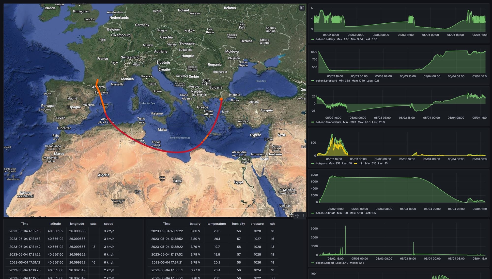
I launched a high-altitude balloon from France that traveled 2,847 km before landing in Turkey. The flight lasted 55 hours, reaching a peak altitude of 7,768 m. The payload transmitted GPS coordinates via LoRaWAN, powered entirely by solar charging with supercapacitor storage.
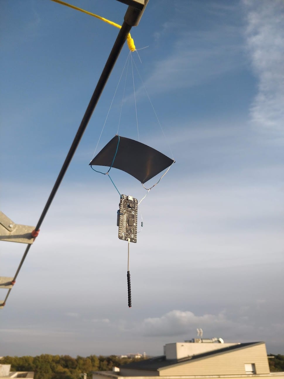
Hardware: Heltec HTCC-AB02S CubeCell
The HTCC-AB02S integrates everything needed for a GPS tracker: ASR6052 chip (ARM Cortex M0+ with SX1262 LoRa radio), built-in GPS module (AIR530Z), and onboard solar charging that accepts 5.5-7V panels directly.
I desoldered the 0.96-inch OLED display to save weight. Deep sleep current is only 21µA, which is critical when solar input is limited.
Why Solar Power with Supercapacitors
The payload experienced temperatures from -29.3°C at altitude to +40.3°C at ground level. Lithium batteries struggle across this range because internal resistance increases in cold and capacity degrades in heat.
Supercapacitors work from -40°C to +70°C without degradation and have unlimited charge cycles. A 3W panel kept them charged even through thin clouds.
Results
Power System
Voltage never dropped below 6.8V even during the longest night (14 hours). The solar panel pulled 180-240mA during peak sun, more than enough to offset the GPS and LoRa transmitter draw.
LoRaWAN Coverage
I used SF12 with 14dBm transmit power. Across the flight, 3,309 packets were received by thousands of Helium hotspots. The maximum distance to a receiving hotspot was 511 km, enabled by the altitude advantage and clear line-of-sight. A single packet reached 852 hotspots simultaneously.
Telemetry
The payload logged GPS position, temperature (-29.3°C to +40.3°C), barometric pressure (1013 hPa at launch to 388 hPa at peak altitude), supercapacitor voltage, and solar current.
Community Response
Flight data was shared across LoRaWAN communities in four countries. Turkish enthusiasts tracked the landing and helped coordinate recovery.
Hardware List
- Board: Heltec HTCC-AB02S CubeCell GPS-6502 (868MHz) with OLED removed
- Power: 3W 6V polycrystalline solar panel with supercapacitors (-40°C to +70°C rated)
- Antenna: Custom 868MHz design, tuned with NanoVNA
- LoRaWAN: SF12, BW125, CR4/5 on 868MHz EU band
Takeaways
Solar power with supercapacitors handles conditions that challenge cellular or satellite trackers. The Helium network's distributed coverage made continuous tracking across international borders possible without deploying any infrastructure.
Total hardware cost: under €100.
Ready to Get Started?
Get expert guidance on implementing LoRaWAN solutions for your organization.
Let's Talk